The title may be a little “misleading” in that you won’t necessarily find all the best hikes in the département here, as this article is subjective… and based on my own experiences! So the list of walks presented here isn’t exhaustive, but it will grow as I add to it with our walks in theAisne and our new favourites… and I still have lots to discover! Also, since we live in Saint-Quentin, we tend to favour walks in the surrounding area!
So feel free to suggest your favourite hikes and routes in the comments at the bottom of the article.
Much as we love hiking, I have to admit, to my dismay, that we’d rather neglected the Aisne’s trails… not entirely convinced by the 2 or 3 walks we’d tried until then. We hadn’t necessarily picked the most beautiful hiking trails in the area.
The end of lockdown in 2020, and the rule limiting travel to 100 km from home, made us reconsider and do some research on the subject.
That’s when we discovered this website developed by the département, a goldmine for walkers keen to rediscover the area, which lets you choose a hike according to very specific criteria (length, type, location…). I have to say I find the site really well done, and I’ve printed out loads of routes since, which make me want to lace up my trainers or hiking boots and set off.
Another source of inspiration : the wise advice of my friend Pierre (Castor), a Vermandois expert and keen angler who knows all the most beautiful ponds around Saint-Quentin, whom I’d like to thank here!
https://www.instagram.com/p/CAyOJ5MjlQw/?utm_source=ig_web_button_share_sheet
These lovely discoveries reminded me of an essential lesson we sometimes tend to forget: the grass isn’t always greener elsewhere… especially when you live in the Aisne, a very green, nature-filled département ! That said, I do of course prefer walks with lakes or hills, like in the Vosges, Wales or Scotland… ^^ (This summer, we’d love to head to the Jura or the Écrins massif :)!)
One doesn’t rule out the other, it takes all sorts to make a world, and our flat country is still full of unsuspected little gems (generally accessible to all walkers, beginners and experienced alike).
Sorry this introduction is so long, but I hope it will make you want to discover our little corners of paradise and serenity.
I’ve placed (roughly) each of the places mentioned on a map to help you find them.
Map: hikes and nature spots in the Aisne

The Sentier des Abbayes (Abbeys Trail):

This slightly sporty hike is one of my favourites in the Aisne! The trail winds through the ages and the woodland, revealing surprises from another time here and there. Between forest edges and clearings, oaks and beeches and lush green landscapes, the first part of the walk is pleasant and soothing. Wear good shoes, though: the path is sometimes stony and slippery! At one point, you’ll come out into a small, more open clearing; carry on to the pretty village of Saint-Nicolas.
Length : 15 km (9.3 miles)
Duration : about 4 hrs 30
Elevation : between 90 and 187 m
Access : from the Parking des Roches car park (take the D7 towards Laon, then turn onto the D730 2 km later). Along the way: the Saint-Gobain state forest, the Roches de l’Ermitage and the remains of many abbey sites
Picnic area? Yes
Route : link
What we love:
- feeling immersed in nature
- the variety of landscapes
- the views of the Benedictine abbey and the Tortoir abbey
- the woodland scents
- finding a bit of elevation in the Aisne
The Riqueval tunnel towing site
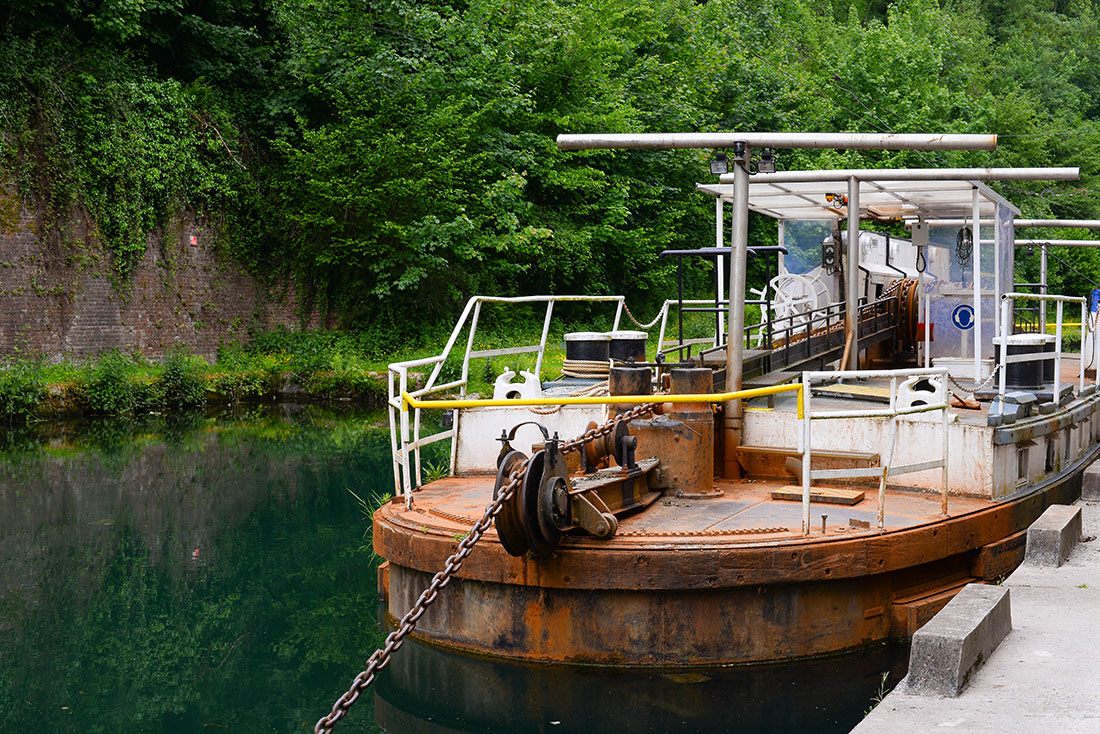
The Riqueval tunnel was built between 1802 and 1810 to let boats on the Saint-Quentin canal pass from the Somme basin to the Scheldt basin, using a towing system in which the “toueur” (an electric winch boat) pulls barges through 5,670 m (3.5 miles) of tunnel!
From the dedicated museum, several hiking trails head into the woods to follow the canal in the cool ^^, while discovering varied plant life, highlighted by a few information boards. The route also lets you walk in the footsteps of First World War soldiers, discovering an old bunker and a (superb) bridge on site, the scene of a major strategic battle in early autumn 1918…
What we love:
- the serenity of the place and the incredible clarity of the water
- the site’s historical value, which you gradually grasp throughout the walk (the importance of the canal, the design and role of the tunnel, Napoleon’s visit commemorated by an “imperial ramp” you’ll walk on the way back, and the site’s key role during the First World War)

The La Salette hike in Guise

Even though I’ve been to Guise dozens of times (I worked there…), I had no idea this (really) lovely hike existed before browsing the website mentioned above. (It’s become my bible!)
The loop climbs above the town (with a superb view of the Familistère) and winds through the Oise valley. It reaches the former Bohéries abbey and then the La Salette chapel that gave it its name. We skipped the towpath section, which was almost impassable and completely neglected, and followed the suggested alternative route straight through Proix, which doesn’t change much.
I particularly enjoyed the variety of landscapes, between grassy woodland and idyllic spots full of varied wildlife and plants, rivers, the canal and impressive monuments. The last part of the walk, through the fields, was very beautiful too. However, I don’t recommend tackling this hike on very hot days: the last few kilometres are very exposed, without a scrap of shade to shelter in, and we suffered a bit!
Length : 15.5 km (9.6 miles)
Duration : about 4 hrs 15
Elevation : modest, between 82 and 149 m
Access : car park opposite the church of Guise (at the foot of the castle)
Along the way: the church and castle of Guise, a rayère, Bohéries abbey, the La Salette chapel in Proix
Picnic area ? Yes, in Vadencourt
Route : link
Also worth seeing in Guise : the castle, the Familistère, the pleasure garden and, nearby, the gardens of Puisieux-et-Clanlieu
What we love :
- the variety of landscapes
- the peace and quiet
- the lovely views of Guise and the Familistère at the start of the hike


The Creuttes de Neuville

Starting from the Center Parcs car park, this little loop takes you up a bit for a unique panoramic view over Lake Ailette. The path winds between forest and pastures dotted with wild orchids, before returning to the lake, where you can discreetly watch the birds!
The hike is fairly short, colourful and accessible to all! It’s a pleasure to walk the paths of this green haven, lulled by birdsong and the rustle of the leaves where the birds take refuge as we pass. The path finally rejoins the greenway. This (short) section is less pretty 😉 but just as quiet!
Length: 6 km (3.7 miles). Duration: 1 hr 45
Elevation: modest, between 80 and 169 m (just one real climb, right at the start)
Access: car park opposite the Center Parcs entrance
Along the way: bird observatory, Lake Ailette, the Henri Boileau Nature and Bird Museum in Neuville-sur-Ailette (400 species)
Picnic area? Yes (I think!)
Route : link
What we love:
- the peaceful setting
- the variety of landscapes
- the views of the lake… from close up and from above!
- the bird observation point


The Rayère of Alaincourt

The hike is fairly short, but very popular locally, from what we saw! Starting from the Maison de Marie-Jeanne, a museum devoted to everyday objects, the 3.5 km trail first takes you through the village streets. I have to admit I’m not a big fan of “urban” hikes, or in this case, walks down the street.
This hike may not be our favourite, but it does have its attractions, with lovely views of the Oise’s meanders and an old water mill, and a quiet walk along the towpath. At the end of it, many locals like to take a dip at the foot of the Rayère, which is very pretty and photogenic. If you’re looking for a nice Sunday family walk, this route is for you.
Length: 3.5 km (2.2 miles)
Duration : 1 hr
Elevation : more or less non-existent ^^, between 55 and 66 m
Access : start from the car park near the tennis court (Maison de Marie-Jeanne).
Along the way : Maison de Marie-Jeanne, an old water mill, the lock and canal from the Sambre to the Oise, a wash house with an adjustable floor
Picnic area ? Yes
Route http://aisne.media.tourinsoft.eu/upload/Microbalade-la-rayere-Alaincourt-Aisne-Picardie.pdf
Note: rayères are old weirs built to power the mills
What we love:
- the reward at the end
- the family atmosphere of this hike
The Saint-Martin-des-Prés hike in Trefcon
I particularly love this area on the border of the Aisne and the Somme, and its green colours. Aymeric pointed out, rather wearily, that we’d been to Caulaincourt more than once to take photos. Yet we’d never followed the hiking trail starting from Trefcon church, a short route that meanders between ponds and forest along the Omignon. I have to admit I didn’t find the trail very well waymarked; in fact, we didn’t spot the ruins (which look rather mystical in our friend Pierre’s photos) of the Saint-Martin-des-Prés church. (Haha, we sometimes struggle when hiking; a sense of direction isn’t my thing!)
The landscape itself is enchanting, as if straight out of a fairy tale on sunny days. You almost expect to see Little Red Riding Hood lost in the undergrowth among the towering trees!
The walk is fairly quick and flat! A little breath of fresh air you can even enjoy at the end of the day if you live nearby ^^!
(Watch out for mosquitoes, though.)
Length: 5.5 km (3.4 miles)
Duration : 2 hrs
Elevation : modest, between 63 and 96 m
Access : start from Trefcon town hall
Along the way : British cemetery in Caulaincourt, the Omignon valley, the Caulaincourt wash house, the ruins of the church of Saint-Martin-des-Prés (remarkable gravestones)
Picnic area ? You can picnic in Caulaincourt
Route http://aisne.media.tourinsoft.eu/upload/Saint-Martin-des-Pres-PDF.pdf
What we love:
- the feel of a forest straight out of Grimm’s fairy tales
- the lullaby of the Omignon’s waters all along the walk

The Isle marshes loop

The loop around the Parc d’Isle is something of a must if you live in the area… Just go there at the weekend on a sunny day if you don’t believe me. Although it can be a bit busy, the walk is pleasant and above all accessible to everyone, especially if you have children. They love the various play areas and the little farm you’ll pass along the way. Personally, I prefer the nature reserve section, halfway along towards Rouvroy. The loop then follows the towpath to the war memorial and the Isle beach. A family-friendly trail, and above all right on our doorstep, for when we feel like some greenery without having to take the car!
Length : 6 km (3.7 miles)
Duration: 2 hrs
Elevation : almost none
Access : start from the Parc d’Isle, between 72 and 81 m
Along the way : Isle Marshes Nature Reserve, mini golf, beach, open-air café and water sports centre, war memorial, station
Picnic area ? Yes
Route : link
What we love:
- how close it is, right in the middle of town
- the simple, family-friendly route suitable for everyone
- the still wild and unspoilt “reserve” section
The Oise valley: Séry-lès-Mézières, Châtillon-sur-Oise

We’re particularly fond of the little pond at Séry-lès-Mézières, its little huts, the lovely light at the start and end of the day, and its teeming wildlife (frogs and dragonflies have made it their home!)
This year, not being sure it would be accessible after lockdown, we opted for Châtillon-sur-Oise, and parked along the canal to wander around at our leisure. Aymeric had spotted a few paths on Google Maps. We didn’t want to commit to a long loop, as we weren’t too confident about his temperamental asthma that day ^^!
One thing’s for sure, we’ll be back: although the ponds were still inaccessible (because of Covid or in general?), the place won us over! It’s a real haven of peace with abundant nature, between scattered ponds, colourful plains and a little waterfall. You can also follow part of the canal to finish the walk in peace and quiet. The Oise valley in the Aisne is a real little gem!
Châtillon-sur-Oise…

Séry-lès-Mézières…
The source of the Scheldt (Escaut) at Gouy

Several routes take you to the source of the Scheldt (Escaut in French) at Gouy. We tried one a few years ago that didn’t exactly blow us away. We enjoyed our second attempt more, in the company of an insider!
It helped us realise the importance of the site: the source of a 355 km (220-mile) European river that crosses 3 countries (France, Belgium and the Netherlands) before flowing into the North Sea. Perhaps you’ve come across it in Tournai, Ghent or Antwerp? Many Dutch people visit every year, keen to honour (and protect!) the cradle of the Scheldt, which shaped the economic and commercial history of the Netherlands. This time, we followed the guide, who took us to the real source of the Scheldt, where the flow never dries up. A little further on, you’ll enjoy an unbeatable view of the Mont-Saint-Martin abbey.
This loop (https://www.randonner.fr/offres/le-berceau-de-lescaut-le-catelet-fr-2161246/) also takes you past a few monuments erected in memory of British soldiers executed during the First World War.

The Panorama des Creuttes

The loop is short (1.8 km) but full of surprises, so I had to mention it here, in case you live near Laon or are passing through. The trail offers a unique view over Laon and the “Tuscany of the North”, with its valleys once covered in vines. At the top of the route, you’ll walk through the charming (flower-filled) hamlet of Mons-en-Laonnois and admire the Creuttes, surprising old cave dwellings built into the region’s limestone cliffs and rocky outcrops. They originally housed the poorest people and are now used as storage or garages. This village lost in the forest is one of the most beautiful I’ve visited in the Aisne.
Length: 1.8 km (1.1 miles)
Duration : 30–45 min
Elevation : from 117 to 170 m (a good climb at the start)
Access : in the centre of Mons-en-Laonnois, head towards Bourguignon (D 652). The car park is 500 m after leaving Mons, on the right.
Along the way : cave dwellings, panoramic views over Mons-en-Laonnois and Laon
Picnic area ? Yes
Route http://aisne.media.tourinsoft.eu/upload/Microbalade-Le-panorama-des-creuttes.pdf
What we love:
- the incredible panoramic view over the surrounding area
- the beauty of the hamlet
- the unusual views of the Creuttes


The rayères of Origny

We particularly enjoyed this hike, which is pleasant even in the rain. Just a bridge away from the Origny sugar factory (which tickles our nostrils every time we pass… and not in a pleasant way, if you see what I mean), another world seems to be hiding: a green, magical universe, lost in the wild loops of the Oise valley. Between ponds, rivers and rayères (old weirs built to power the mills), water seems to have sculpted the surrounding green landscape. The path, sometimes through woods, sometimes through fields, is soothing and fairly easy to follow.
Length: 15 km (9.3 miles)
Duration : 4 hrs
Elevation : between 70 and 125 m
Access : car park opposite Origny station
Along the way : the banks of the Oise and the Sambre–Oise canal, the Bloucard cliff, Stevenson’s route described in his travelogue An Inland Voyage, the brick church of Bernot
Picnic area ? I think so
Route http://aisne.media.tourinsoft.eu/upload/Les-rayeres-V2.pdf
Many thanks to Amélie for the discovery!
What we love:
- the feeling of having stepped into another world
- the shimmering colours everywhere
- the lovely landscapes around the water


The Hottée du Diable

In the Aisne, the Hottée du Diable needs no introduction: mystical stone giants with curiously animal-like shapes, sitting on a sandy mound in the heart of a forest of heather, oaks and birches. Several hiking trails take you to them from Coincy: this short 2 km loop (https://www.randonner.fr/offres/la-hottee-du-diable-coincy-fr-2161690/), or this slightly longer route that takes you through the village of Villeneuve-sur-Fère, where Paul Claudel lived.
We followed the first one. Coming from Saint-Quentin, I have to admit I know the walks in this area less well, but this little forest walk leading to one of the most beautiful pictures created by erosion seems a must if you’re passing through or live in the southern Aisne!


The Blangy waterfall
Length: 8 km (5 miles)
Duration : 2 hrs 15
Elevation : modest
Access : Hirson football ground car park
Along the way : former glassworks, former foundry
Picnic area ? Yes
Route http://aisne.media.tourinsoft.eu/upload/a3-LA-CASCADE-DE-BLANGY.pdf
Note: allow for a little detour to get closer to the waterfall
The Blangy waterfall, in the heart of the Hirson communal forest, needs no introduction either, and can be enjoyed in any season. A short hike from the town takes you there, after a lovely walk through the forest (very beautiful in autumn, as I remember)!

The source of the Somme at Fonsomme

Have I already told you about the river Somme, from its Roman name Samara (taken from Gaulish words: samo, calm, and ar, river or valley), the longest river in Picardy (245 km), which flows into the English Channel at Saint-Valery-sur-Somme after crossing the Picardy plateau through a maze of ponds, peat bogs and marshes…? No?
It rises in Fonsomme, a small village 15 km from Saint-Quentin. The former Abbey of Fervaques, from the Latin “Ferventes aquae”, gushing waters, once stood here! The place is pleasant, friendly, ideal for picnics and surrounded by hiking trails, perfect for a day in the countryside.
I have to admit I’ve never followed a particular route, but this 1 km loop from Morcourt might tempt me: http://aisne.media.tourinsoft.eu/upload/La-Somme-naissante.pdf (It does look quite exposed, though, so perhaps avoid it on very hot days!)
The Somme valley: around Seraucourt-le-Grand
(Seraucourt-le-Grand, Contescourt, Castres, Fontaine-lès-Clercs)

This hike really is one of the prettiest in the Aisne, and has a timeless feel! You’ll pass a myriad of ponds full of carp, among other fish, mirroring countless willows, alders and poplars…
Then turn onto an old, now-abandoned 1930s bridge, for a guaranteed Walking Dead atmosphere! Nature is gradually reclaiming its rights, perhaps offering a glimpse of the world a few thousand years from now. In any case, you’ll enjoy a simply incredible view over the Somme valley… Almost translucent waters in stunning colours! It was a feast for the eyes!
The route also lets you observe varied wildlife (you’ll be accompanied by dozens and dozens of dragonflies!)… But I have to admit that this year our attention was mostly taken up by mosquitoes. Bring repellent!!
After Castres and Fontaine-lès-Clercs, you’ll rejoin the towpath for a lovely end to the walk along the canal. At the end of the path, a little chalet lets you have a drink or refuel with a good ice cream ^^!
A wave to our other hiking companions: Nelly, Alex, Kevin, Silbann :)!
Length: 8 km (5 miles)
Duration : 3 hrs
Elevation : modest
Access : car park after the church in Seraucourt-le-Grand
Along the way : old bridge, Somme marshes
Picnic area ? Yes

I hope all these walking ideas will be useful :)!
If you enjoyed this article, find it on Pinterest!